Ruby Mines near Mogok

On the Ruby Mines near Mogok, Burma
by Robert Gordon, C.E.

With Pala Presents, we offer selections from the library of Pala International’s Bill Larson, who shares with us some of the wealth of information in the realm of gems and gemology. The following article was published in the Proceedings of the Royal Geographical Society and Monthly Record of Geography, read at the Evening Meeting, February 27th, 1888 (Vol. 10, No. 5 [May 1888], 261–275).
When Upper Burma was annexed to the Empire in 1886 negotiations were opened with commercial firms for the working of the ruby mines near Mogok, some 60 miles north of Mandalay. Among the competitors were Messrs. Streeter & Co., who were requested by the Government to send representatives to the mines, and I was asked to survey and report on the mining district by the concessionaires. Every facility was offered for the survey by the authorities;* and by the courtesy of Mr. E. W. Streeter, F.R.G.S., I am permitted to offer a brief account of that famous acquisition and to present the map to the Society.
*Beyond the kindly courtesies or General Stewart and his staff I am specially indebted to Captain Hobday, R,E., and to Mr. H. J. Richard, C.E., for the sketch maps made by them of the routes to the Ruby Mines.
2. This region, which has hitherto been closed to travellers, may now receive more attention, and a few words on the way to it will not be out of place. The weekly mail from London reaches Rangoon in twenty-three to twenty-five days; and direct steamers do the ocean route of about 8000 miles in thirty to forty days. Formerly the only route to Mandalay was the river journey of some 600 miles, which took two or three weeks to accomplish, owing to delays at intermediate stations for cargo; but now 160 miles of rail to Prome on the Irawadi cut off one-half the distance in a few hours, and express steamers run thrice weekly between Prome and Mandalay, in three days up and two down. This river route will always be attractive, owing to the scenery and the interest attaching to the river and to the places upon it. The down journey may often be made this way, when time is no object, even after the opening of the new railway far inland to the east, in 1889, which will enable the distance of 400 miles between Prome and Mandalay to be covered in less than twenty hours.
3. The river has often been described; and the comparatively unattractive railway line is not without interest. It is bringing about economic changes of the highest importance. In 1864 I examined the country between Rangoon and Pegu for a road, and found the greater part uncultivated plains covered with trees or elephant grass. The remainder of the line to Tonghoo Wall long afterwards described as valueless jungle and swamp lands for a great portion of the distance. At present, 162 miles of railway are opened to Tonghoo and pass through rich cultivation and wild lands rapidly being reclaimed and transformed. The local traffic is already heavy, and with the through traffic to the Shan States more than pays for working.
4. It is a continuation of this line which is to reach Mandalay. The two valleys of the Sittang and of the Samone, a branch of the Myitgney, form a plain which rises only a few hundred feet above sea-level at the water-parting. In the southern valley there is a heavy rainfall and luxuriant vegetation; but the northern one comes within the area of comparative dryness and the dense forests of huge trees, with impenetrable undergrowth of creepers and tangled grass, give place to smaller tree and shrub jungle alternating with cactus and prickly pear and other thorny plants. The ground, however, is culturable; and the mountain streams from the high Shan plateau lands and mountains which rise steeply close to on the east, with the lower drainage basins of the Pegu Toma Hills on the west, have been admirably adapted to systems of irrigation in the plain lands. The plains near Kyouksay are amongst the most fertile in Burma. Projects are being considered for extending this irrigation scientifically under Government control, so that in a short time the entire railway may pass through a richly cultivated country with greatly increased local traffic, besides tapping the Shan trade routes, while it will have immense importance also in facilitating civil and military operations in Upper Burma.
5. Its chief interest, however, will lie in the fact that the new line forms the first instalment of the great iron highway for British commerce to South-western China in the near future. Valuable as the Irawadi route must always remain for heavy traffic the disadvantage of the slow steamer transit to Bhamo, which place, though only 800 miles from Rangoon, takes longer and is more costly for freight to reach than London, makes the extension of the railway to Bhamo indispensable for passengers and light traffic, which can then easily arrive in thirty hours to the frontier of China from Rangoon. A continuation of the railway within Chinese territory for 600 or 700 miles along the old trade route will reach Yunnan-Fu, the capital of Yunnan, and a further extension of the same length to Su-Chau-Fu and to Chung-King-Fu will place the principal marts of Sze-chuen and the navigable channel of the great artery of China, the Yang-tse-kiang, within 100 hours from Rangoon, with less than 2000 miles of railway, varying in cost from 6000l. to 10,000l. per mile, so that an expenditure of 14,000,000l. sterling, of which 3,000,000l. has already been incurred, will bring Central China within twenty-six days' reach of London. The country to be passed over is easier than that crossed by the mountain lines of Colorado, and is in every part within territory subject to the direct authority of the Governments of India and of China.
6. From Mandalay to the Ruby Mines the river route is usually taken to Thabyetkin or Kyanyat. The latter place, situated nearly 90 miles up the river, being chosen as the base of the military expedition, I took steamer for there on the 15th December, 1886. Two flats were in tow, one of which carrying military stores and live¬stock, struck a snag on the second morning, and was rapidly sinking, when she was run on a sandbank to save her. There all three vessels remained for four or five days, giving the passengers time to examine the Mingoon Pagoda, the greatest mass of brickwork in the world, with the immense bronze bell, reported to be the second largest existing, which are fully described and figured by Colonel Yule in his 'Mission to Ava.' We were warned that the neighbourhood was thick with dacoits, and we saw a party of the new Sikh police in pursuit of a gang, with two or three of whom they presently returned as prisoners. The dacoits had completely paralysed the boat traffic on the river, and parties of bluejackets from war ships in Rangoon were actively engaged in suppressing them. A few days afterwards, on the 9th January, Lieut. Macdonald, in charge of the bluejackets, was killed at Sheemagay, a short distance above where we were stranded. Although the steamer and flats only drew a little over 3½ feet of water, the river was so low and the channels so bad, that all vessels passing had to be dragged over different bars by their cables, and it took our steamer twelve days to reach Kyanyat. It was not only the portion of channel between Mandalay and Bhamo that delayed traffic, as extensive bars formed near an acute bend of the river in the delta near Kyunghun, completely blocking the navigation for over three weeks in March and April 1887. During the present dry season of 1888 the river is reported to be worst than ever before known in this respect.
7. The Thabyetkin route crosses a low part of the Shwey-oo-doung Hills, a small isolated range running parallel to the river in the lower defile. It keeps throughout on high ground, entering the ruby region from the south near Kyatpyen, with 50 miles of river route and 40 by road. It has been chosen as the permanent road to the mines. and is now being much improved; but it was not open when I went up, so I followed the road just passed over by the expedition, which runs for 40 miles through plains partly subject to inundation in the rains, and for 20 to 25 miles in the hills. Extensive forests cover most of the lower country. Jungle fowl and partridge abound, but large game is rarely seen. Monkeys are abundant. When I passed, a telegraph line was being hurriedly put up to connect with the troops, and the officer in charge pointed out a tree very widely prevalent which the coolies declared to be dangerous to cut down. Not only was its juice poisonous, causing painful sores on the skin, but its exhalations were said to be baneful, and malevolent spirits guarded it. This region is fever-haunted. It caused much sickness to the troops and camp followers, both Burmese and natives of India. The fever-belt runs right through Burma, at the bases of the mountain ranges, in parts corresponding to the Terai of the Himalayas. The people from the lower plains seem more subject to the fever than those from the hills. One feature of the fever in this locality was that those who had suffered from fevers elsewhere seemed less liable to it than those who had never been affected before. Experience has shown that the new road on higher ground is also feverish, but when the approach is completed to the sanitarium lately established the bad parts can be rapidly passed through and the colder high grounds be quickly reached.
8. This sanitarium, called Bernard-Myo, after the first Chief Commissioner of the new province, is situated on the broad rolling plains of Enjouk, on the northern slopes of the hills bounding the mining districts. It stands at an elevation of over 6000 feet above sea-level. Colonel Cubitt, who commands the force in the Ruby Mine districts, has now lived in the Enjouk valley for several months, and writes that it is one of the healthiest sanitariums in India, or in the world. The road rises continuously to these plains from Sagatoung, generally through thick forest, from which most of the teak timber has been extracted. As the higher parts are reached magnificent views open out of the country below. In the early morning dense white fogs are apt to shut out the lower plains; but Shwey-oo-douug, whose conical peak, rising some 5000 foot above sea-level, has been the most conspicuous object coming up the river, stands out clear and distinct to the south-west. In the far distance westwards the Arracan Hills form a noble background to the Irawadi, whose generally straight course can be traced running north and south for many miles. As the mist disperses, the immense plains of forest land are seen below with a few isolated clearings of cultivated ground, showing what a scanty population there is. Immediately below, however, there is a small valley, with a north-easterly direction, whore cultivation and houses appear more extensive and numerous; the lands belonging either to the Momeit Shans or to the ruby districts. Several small villages were passed on the way to Enjouk, nearly all deserted after the fighting; but I met some Chinese who had been settled in the neighbourhood for many years, and who returned to their homes when the troops went on. Should continuous residence prove Bernard-Myo to be in all respects favourable as a sanitarium it will be a great boon for Burma, which has hitherto been without a health resort.
9. The Enjouk plains are open, with few trees about; but to the east rises a range of hills with blackened crests, and flanks covered with masses of dense forest, whose dark foliage gives the name of Toung-Meh, or dark mountain, to the most prominent peak. The road descends from Bernard-Myo to reascend to the pass over the ridge at about 6200 feet. It passes a curious barrier of rocks where the last stand was made against our troops. They form a row of obelisks some scores of feet high, and they are found in a similar row, but on a more extensive scale, in the next valley on the road to Kathey. They are of limestone, black outside from the weather, but, when broken, presenting a pure white fracture. This limestone appears to form the axis on which the gneissic rocks have been upheaved. It protrudes at various points, but its flanks are covered with the disintegrated metamorphic debris. Ferns abound in the damper nooks of the rooks and the trees, &c. The trees are often covered with orchids, some rare ones, and many of great beauty. The view is confined to the pathway until a considerable descent is made, when a charming scene suddenly opens out with the rolling wave-like hills beyond and the narrow valleys below.
10. Presently a streamlet is crossed, with artificial channels led from it to contour the hills, indicating irrigation or mining operations. It proves to be the latter, for though many similar channels are met with in several parts of these valleys, little cultivation by irrigation was seen. In the Kachyen Hills to the north irrigation is generally practised, the water being led to the rice-fields on the terraced hill-sides. The valley now entered is that of Yay-Boo, which occupies a central position relative to the Mogok and Kathey valleys. The ruby-bearing region, so far as known, lies within an area 10 miles long by five wide, and consists of groups of small valleys nestling beneath the Toung-Meh range, and to the south of it. The Enjouk valley to the north is said to yield rubies and sapphires, but they have not been regularly worked. The valleys arrange themselves into three groups of nearly equal area by the distribution of the watercourses. To the east a few streams unite to form the Yay-Nee, or red water, so called from the washings of red earth from the mines. This drains the Mogok valleys. The Yay-Boo stream meets the Yay-Nee a short distance below Mogok. with the drainage of several minor valleys constituting the Yay-Boo group. The Kathey and Kyatpyen valleys have separate streams, which do not join the Yay-Nee till they pass out of the ruby region, when they unite with other branches from Mainlong to form the Madeeya river, which enters the Irawadi just north of Mandalay. A road follows this river line from Mandalay to the mines, and if there were likely to be a very heavy local traffic, it might be worth while to develop it; but the present route is extremely rough and bad1y chosen, and passes through disturbed tracts of country.
11. I surveyed the principal roads in the valleys, fixing the positions of the peaks and principal villages. The heights are mostly taken from the military surveys. The valley plains range from about 4000 feet near Mogok to 4800 near Kyatpyen, while the ranges vary from 6000 to 8000 feet in height. The main valleys offer fine views of bold scenery, backed by black mountain masses and dark forests, while the lower rolling grounds and steep hill-sides of brighter green are variegated with red and white land slips, indicating occasional heavy rainfalls. All the plains and lower slopes within easy reach of the villages have been denuded of trees for fuel, but the other parts are generally thickly wooded. Every prominent elevation of the lower hills is crowned with a conical-shaped pagoda, and the chief places are surrounded with smaller pagodas, richly carved monasteries and shrines, as well as with substantially built rest-houses for travellers or traders. Everything indicates the possession of surplus wealth and the liberality of the people. There is a condition of general wellbeing and comfort apparent in the houses and surroundings. The houses are of wood, of the Burmese type, with raised floors and mostly thatched roofs; but the colder climate requires them to be more solidly and compactly built than those in the lower plains. As a rule, they are surrounded by inclosures, often fenced with blush roses. The cultivation generally seemed very backward when compared with that of the Kachyens and Chinese Shans to the north, near Bhamo, where, with no greater fertility of soil, apples, pears, peaches, plums, and potatoes abound, as well as the more usual fruits and vegetables of the country. The amount of cultivation within the mining region is small and insufficient for the people, few as these are. But agricultural communities lying outside the territory have long been attached and subject to it.
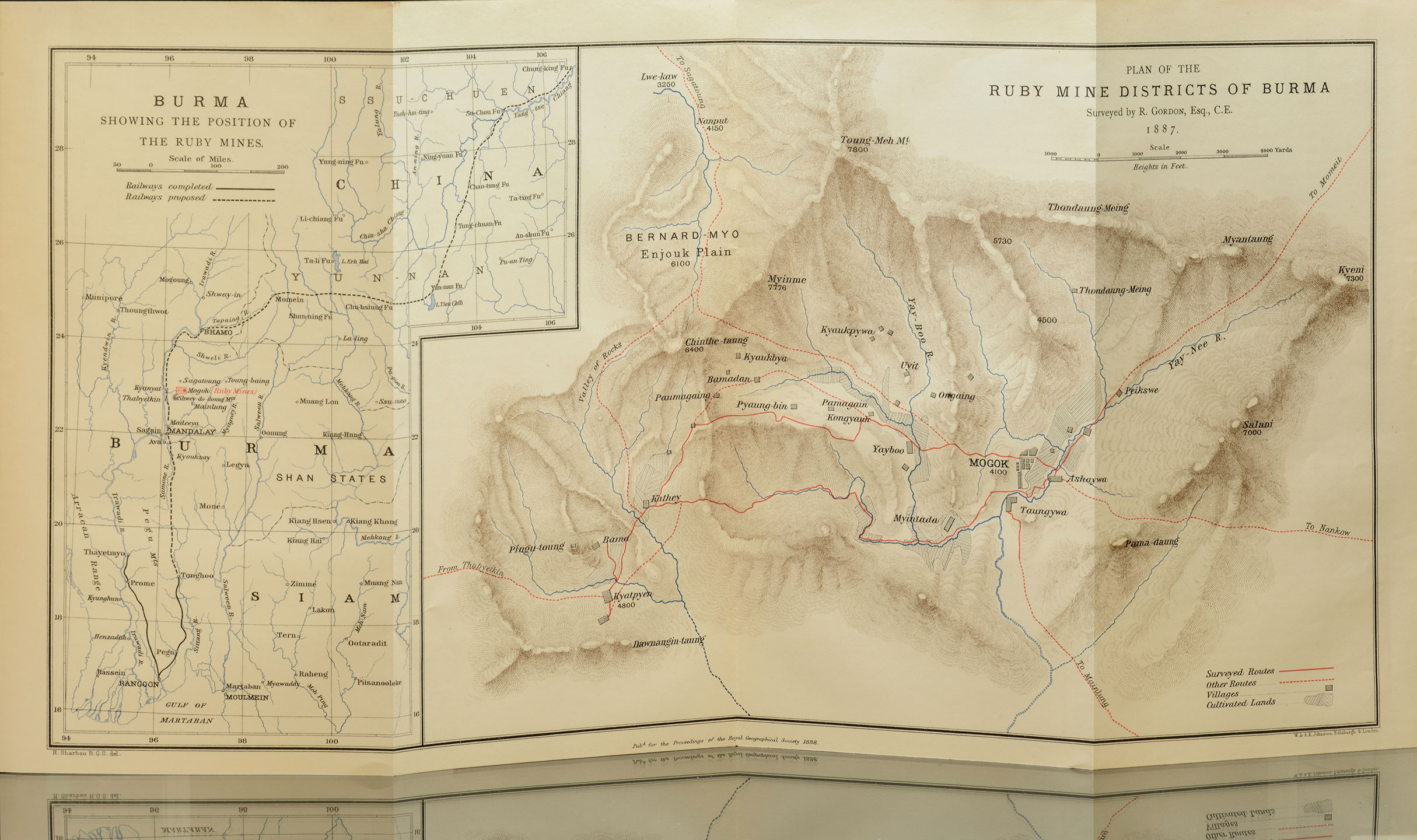
This map accompanies this article. At left, the ruby mining district in its international context. At right, drilling down on the district. Click to enlarge.
12. Thus Mogok is shown, in an official document of the late Burmese Government, as containing 170 houses within the village itself, and over 260 houses in fourteen other villages in the Yay-Nee and Yay-Boo valleys, all within the mining districts; while outside these, in purely agricultural districts, there were seventeen villages with over 400 houses. None of the latter is shown on the map. Kyatpyen had ten villages with 160 houses concerned in mining, with six villages and 90 houses devoted to agriculture; the figures for Kathey being seventeen villages with 160 houses, and two villages with 100 houses respectively. Beyond this a floating population of traders and coolies exists near the principal places; but probably, with an average of five persons to each house, and outsiders, there may be a population of from 5000 to 6000 in the mining districts, with half as many more in the agricultural villages.
13. The most remarkable thing is the distinctness and diversity of races among the peoples in the different communities, who evidently have kept themselves from intermarriage with their neighbours for centuries, and a brief notice of the tribes whose types are found here may not be out of place. In Kathey, as the name implies, the villagers are Katheys, whose ancestors were brought as prisoners from Munnipore very long ago, as they have lost both the Hindoo religion and their own language. In Mandalay, Prome, and Henzadah, where bodies of the same people have been long transplanted, they keep their race and religion pure still. The ethnologist would find matter of intense interest in the interactions of some of these races upon each other, and perhaps the history of these transplanted Katheys would yield the most curious results. When surveying for the railway in the district south of Mandalay, I found them extensively distributed throughout the country, always living separately in their own villages, and retaining many of their peculiar characteristics, even when they had become thoroughly Burmanised in their speech, religion, and general habits. They are colonies of pure Aryan race, retaining the features and colour and physique of their Indian ancestors, although surrounded for centuries by Turanians of great assimilating power, whose cordial hospitality and tolerance tend to modify and absorb most of the races. coming into close contact with them. None of the yellow races of Burma, or Siam, or China, milk their cattle, and it is difficult when travelling in those regions to get a supply of this very useful article. Near Mandalay, and to the south of it, however, the Katheys have accustomed many of the Burmese to the use of milk, and it is perhaps the only part of Burma where it could be got in the country places. The Katheys are clever and industrious weavers, and they produce in Mandalay, and in several rows of villages on the lower part of the Myitgney river, very richly coloured and variegated silks, which cannot be imitated by machinery. When the whole of the Mandalay and Kyouksay districts were overrun with dacoits in 1886, almost the only villages which remained unburned were those belonging to Katheys on the Myitgney. These were strongly stockaded, not only at the outer village fences, but often from house to house, and were prepared to offer strong resistance to attack. It seemed at first sight as though their immunity depended on their peacefulness and on their keeping aloof from the quarrels of rival pretenders to the throne, and submission to the British; but a night attack and massacre of some twenty-seven armed police within five miles from Mandalay, early in 1886, was found to have originated in one of their villages, and there was reason to suppose that some of them were more loyal to the deposed dynasty than many of the Burmese.
14. In Bama and other villages at the mines the people are Paloungs, who keep up intercourse with the tea-growing Paloungs on the hills to the east, and preserve their language, although, like the Katheys, they have become Buddhists. Less is known of the Paloungs than of most of the great tribes bordering on Burma. They differ in speech, and claim to differ in origin from all their neighbours. They occupy a wedge-shaped territory of mountains and plateau between the Ruby Mines of Burma, the Shan States, and China; their principal State being called Toung-baing, which has nominally been subject to Burma, but which from its inaccessibility, has been practically independent. The chief last year refused to acknowledge British supremacy, but an expedition this year will probably bring about a formal submission. The region is known to the Burmese as the La-pet Toung, or Tea Mountains, as it is the part from which great supplies of tea in a dry or in a pickled state are brought. The Paloungs who cultivate it appear to be a quiet, unaggressive people; and they do not themselves bring their produce to the Burmese markets, but sell it to trading caravans of Shans and Panthays.
15. In Kyatpyen the people claim to be of pure Burmese stock. They dress, however, in Shan costume of blue or white trousers and jackets, which is very unusual for the Burmese, whose ordinary costume resembles the Scotch kilt. When the troops occupied the Ruby Mines the Kyatpyen people were the last to come back to their homes. Whether it was that they had taken more active share in the resistance, or had run away the farthest, is uncertain, but they offered the humoursome nonchalance peculiar to their countrymen on their return. As a rule the Burman dreads the cold hill-countries, and he makes a poor colonist to them, although his descent is derived from the Tibetans through the Kyin tribes of the western mountains.
16. In Mogok the permanent residents are all Shans, but Burmanised. As Prof. de Lacouperie has ably shown, the Shans are a portion of the aboriginal people of China, driven before the hordes of Chinese from the north to the southern regions. Under an apparent conformity to the surrounding conditions they become Burmese, or Chinese, or Siamese, as to dress and manners, and modes of life, and sometimes language; but they retain more than any of their neighbours their independence and individuality, presenting complex results which will make them one of the most interesting studies in the near future of Burma. They possess a power of organisation and of self-government which has enabled them to form themselves into clans and nations. At one time a Shan kingdom possessed Upper Burma, and even now Siam is a Shan nation, while most of the intermediate region between these countries and China is possessed by Shan clans and tribes. These seem to be incapable of acting together, and internecine warfare appears to have been rife for ages, without having been pushed to extremities. It may safely be predicted that any attempt to subject these scattered tribes and States to the hard-and-fast regulations of British rule will be attended with disastrous results, and will contrast unfavourably with the native and Chinese rule, which allowed them to govern themselves, electing their own chiefs from the hereditary families, and to settle any little difficulties amongst themselves by a free fight now and then.
17. Separate communities of pure Chinese and of Mahommedan Chinese are found as permanent or as temporary residents. I came across Chinese agriculturists, and there are villages of Chinese who cultivate pork; but the genuine Chinaman is generally a trader or artisan when he is found in Burma. The Panthay Chinese are descendants of the Mahommedan immigrants from the West who settled in Yunnan centuries ago, and their longer features and more upright forms discriminate them from their neighbours. They are perhaps the greatest travellers on the face of the earth, if we may distinguish between those who are carried by trains or steamers and those who travel on their own feet. Every year numbers of these men come from Yunnan to Rangoon and Maulmein, doing thousands of miles on foot, with caravans of ponies, mules, or cattle, to exchange the productions of the country for the imported wares of Rangoon. The railway will relieve them of their long journeys; but as distributors of merchandise on the off lines they must long remain unrivalled. They are exceptionally well informed as to the geography of the countries they traverse, and details can be filled in to maps from their accurate descriptions of places and features. In 1868 Sir Edward Bladen led an expedition to open up trade with the Panthay kingdom which had then been established some years in Yunnan, and was most hospitably received. It is said that formerly some 70,000 mules used to come yearly from China to Mandalay alone. No definite information is now at hand as to the traffic generally, but it still continues to be immense, supplemented as it is by the Shan caravans from the Shan States and Tea Mountains to the numerous marts in the Burmese plains.
18. Beyond these principal peoples, we find in this small locality, attracted by its wealth and its markets, bodies of Mainthas and of Leesaws, who come as temporary visitors. Although the Kachyens are near neighbours to the north, the powerful Shan State of Momeit prevents their irruption in numbers to the Ruby Mines. The Mainthas are either Chinese Shans of a different type from the main body, or are hill Chinese from the North-eastern Chinese Shan States. They come in large bodies of heavy powerful men to do the hard work at the mines and on the roads; generally working as labourers in the dry season, and returning to their homes some hundreds of miles off in the rains. The Leesaws are hill-men of weaker physique, who occupy the mountain regions of Western Yunnan, and are found in isolated communities in the higher parts of the Northern Shan States. They are supposed to be of the same tribal origin as the Burmese, but to have been driven and kept in the more inhospitable hill tracts to the north. They bring firewood, and vegetables and other food, to the fairs held every five days in the principal villages of Mogok, Kyatpyen, and Kathey. The residents of the larger villages rarely do any heavy work at the mines themselves. They engage labourers, advancing them money and necessaries, and sometimes giving them a share of the profits, if any.
19. Careful inquiries were made regarding the rights of the people and their relations to the old Burmese Government. Theoretically they bad no rights of any kind. The monarch was the sole proprietor of the country by conquest, with the people tenants-at-will; but, practically, everything indicated considerate treatment and kindly relations. Their taxes were, however, just double those of other parts of Burma. Lessees of the Government had representatives at Mogok, at Kyatpyen, and at Kathey, and in them was vested the authority for collecting taxes. The communities kept order, and the isolation in which they lived made this easy. Although the custom seems to have been to engage mercenaries for any fighting, the difficulties of access and the facility of defence made them secure from attack except by powerful bodies. Most of the villages were stockaded, and in different parts small escarpments on the tops of low hills told of determined resistance to attack in former days. But all tended to show a settled and peaceable condition amongst the inhabitants in recent times, with a greater accumulation of wealth amongst the headmen than was possible elsewhere under the native rule. Bridges of a substantial character cross the streams, and roads made with much trouble and expense connected the villages to each other and with the outer world.
20. No permanent mining works of any value exist; but numerous artificial water-channels are carried with easy slopes on the hillsides, the ravines being crossed by temporary aqueducts on bamboo framing. The mines are of three kinds: the first, which is of the least importance at present, but which may be the most valuable in the future, consists of workings in fissure veins of soft material which are found imbedded in the crevices of the hard rock caused by shrinkage in long past ages. It is probable that volcanic action accompanied the upheaval of these mountain ranges, and that the already formed rubies were thrown up with a matrix of complex structure since disintegrated by long weathering together with the metamorphic rocks clothing the skeleton of the old mountain limestone whose ribs still protrude. But there is no sign of any recent volcanic action in the neighbourhood; and the corundum is now found disturbed through the clay formed from the breaking down of the gneissic rocks, and also in layers or beds in the valley bottoms near the river, apparently discriminated and arranged by water action. The crevices in the older rocks give origin to cave mines, which are called "Loos," where the soft earth is excavated in a primitive fashion and on a small scale. Very little protective work is used, or regular passages made; the fissures being followed until falls of rock, or choke-damp, stop the way, when the mine is abandoned. An isolated pagoda-crowned rock just north of Mogok offered examples of such caves, now partially filled with earth again; and Pingu-toung, a steep hill overlooking Bama, is rich in such mines, which, however, are frequent through the valleys. At the latter place three men had recently been killed by the falling in of a mine; and again, in July 1887, three more were killed through a similar catastrophe. It is evidently desirable that scientific methods of mining should soon be introduced.
21. The second class of mine is called "Myaw," or washing, and corresponds, but on an insignificant scale, with the hydraulic mining in California. The water is conducted by the channels before mentioned to the lower hill-sides which consist usually of the softer remains of the secondary rocks in reddish or lighter coloured clays, containing rubies and sapphires, though few and far between. The clay is cut into thin slices with a gardener's spade, and washed from the funnel-shaped excavations through flumes or open timber channels, where the clay is dissolved away, or carefully examined for the stones. No attempt has been made to wash the hill-sides by water under pressure. The most extensive works of this kind are close to Mogok.
22. The third and, at present, the most important class of mines is found in the flatter lands of the valleys, where, whatever be the absolute height of the ground, or whether in the neighbourhood of Mogok, or Yay-Boo, or Kathey, or Kyatpyen, at depths varying from 10 to 30 feet, there is found a layer of corundum from a few inches to a few feet in thickness. It is difficult to account for the existence of this layer of nearly pure corundum lying on a bed of earth in which no stones are found, and covered by a similar layer of porous earth. Can geologists explain why for ages the water should have selected earth free from rubies, and then for a lengthened period have brought down and deposited nothing but ruby sand and stone, to again cover it up with common earth? Sir Edward Sladen informs me that in Arracan he found garnets similarly deposited in a layer eight inches thick, four feet from the surface, while the ground above and below it contained none. The corundum layer is generally free from any admixture of clayey earth, and when brought to the surface myriads of small rubies glitter in the sun. They are mostly too small to be valuable, and the mass undergoes careful search for the larger stones, which are selected and classified according to colour, size, and freedom from flaws. It is but rarely that a stone is found which proves to be satisfactory under all three heads. When once the corundum layer, called "Pyon," is extracted, the pits are abandoned to fall-in in the softer material, but to be permanent sources of danger where the ground is firm, as in the neighbourhood of Kyatpyen, where pits overgrown with weeds come close up to the footpaths. The earthy hummocks of the abandoned mines form a remarkable feature along all the principal watercourses of the lower parts of the valleys.
23. The ruby is rarely found in the crystal form; the stones, whether in the smaller grains or in the larger sizes, being water-worn or of irregular shapes, as though split up in contracting; and it is well known that it is extremely rare to find a ruby without a flaw in it. Good stones of proper colour, nearly flawless, and ranging from three to five carats in weight, are very much more valuable than the best diamonds of the same weight. Beyond five carats in weight they are so rare in the best quality as to be of immense value. We hear of historical large diamonds, but large rubies of perfect colour and flawless are mythical. The extraordinary thing about this is that the sapphire is, so far as chemical analysis can show, identical in substance with the ruby (both being a carbonate of alumina), and it is found in the same neighbourhood with it, of small and large sizes, and good and bad colours, often free from flaws. Evidently the difference in constitution which causes the change of colour brings with it the shattering of the larger pieces of the ruby stones. A three-carat diamond of finest water is worth 150l., but a good ruby of the same weight and quality is worth 1500l.; a five-carat diamond may be worth 300l. at the utmost, while a similar weight of ruby is worth 3000l.
24. It is premature to forecast the future of the Ruby Region, but with the careful handling which it is sure to receive from the new governing powers, we may fairly expect a rapid development of the mineral wealth, but would also hope that its exceptionally rich advantages of soil and climate may also be fully utilised to convert it into the garden of Burma.
NOTE.—Rainfall for the eleven months this year, sent by Mr. Streeter's agent from tho mines, Mogok, as follows:—
| inches | inches | |||
| January | 2.30 | July | 20.87 | |
| February | 0.00 | August | 13.91 | |
| March | 0.67 | September | 13.99 | |
| April | 2.82 | October | 4.33 | |
| May | 11.13 | November | 1.27 | |
| June | 15.14 | |||
| Total for 11 months, 86.43 inches. | ||||
After the paper,
Mr. E. W. Streeter read some extracts from letters recently received from Mogok. On May 21st, 1887, Mr. Allay wrote:—"In April, when mining first commenced, there were thirty licenses granted by the Chief-Commissioner, employing 346 miners.—It has rained every day for the last three weeks.—Cultivation here will be small this year, as a number of ploughing buffaloes were stolen some time ago by dacoits.—The servants are all down with fever, and the native doctor as well; he will probably soon be replaced. The Deputy-Commissioner is also down with fever, and will have to leave later." On September 3rd, 1897, he wrote:—"The amount of money received by the Indian Government from June, July, and August ruby sales was:—From Streeter's Syndicate, R.2916 = 194l. 6s. 3d., and on rubies not bought by them, R.1882 = 125l. 9s. 4d. Eighty-three more licenses have now been granted in the three townships of Mogok, Kathey, and Kyatpyen, which employ 927 miners, and produce royalty to the Indian Government to the extent of R.2175 which, taking the rupee at 1s. 4d., equals 145l. In conclusion, Mr. Streeter stated that the Government, in not carrying out the concession entered into by Lord Dufferin, had lost in the year (pro rata) 3¾ lacs of rupees, equalling 37,500l. With great difficulty I have obtained the population of the three townships where mining is carried on, viz.: Mogok, 714 houses, containing 3392 inhabitants; Kathey, 405 houses, containing 1725 inhabitants; Kyatpyen, 302 houses, containing 1553 inhabitants. How many working miners there may be in this total of 6670 souls, I have no means of judging, but it must be something like this:—1000 to 1250 men, 1000 women, and 4000 children, out of whom there may be about 1200 able to work." The ruby probably owed its colour to the presence of some compound of chromium. It was generally of a carmine, cochineal, or rose-red colour, with a play of violet; but the most valuable was the colour of pigeon's blood. The two most important Indian-cut rubies lately seen in the English market weighed, one, after recutting in London, 38½ carats, and was sold for 20,000l.; the other, also recut, weighed 321 carats, and was sold for 10,000l. These rubies were considered of so much importance in Burma, that they were escorted from the palace to the vessel by a military guard, and brought direct to London. The ruby of pigeon's-blood colour, when examined by the dichroscope, exhibited two tints, the one aurora-red and the other carmine. The composition of a ruby was pure alumina, with a minute trace of colouring matter. Its specific gravity was about 4, and its hardness 9, or slightly under. Its system of crystallisation was hexagonal; the common form being a double six-sided pyramid. The Burma sapphire differed somewhat from the sapphire found in Ceylon, Kashmere, Siam, and Australia. It was of a very dark and rich velvety blue, while the Ceylon sapphire was of a much lighter blue. Occasionally, however, a very fine stone was found in Ceylon, but it always had the distinctive mark of silk, either in or on it. The Kashmere sapphire was of a pure blue, somewhat of the colour of the corn-flower, sometimes of a dark velvety colour, but rarely without milky lines of silk. The Siam sapphire was of a dark, dull colour. The Australian sapphire was of no value. The Kashmere mines were worked by means of tunnels through the rocks; but in Siam sapphires were found in the alluvial soil. In Ceylon the stones were water-worn pebbles, found in the river beds. In Australia they were found in the tin mines. The sapphire was blue corundum, while the ruby was a red varietv of the same species. The crystallisation was the same in both stones, and they were found under similar conditions, the only difference being that the ruby was mostly found in fragments, while the sapphire occurred in rolled crystals or pebbles. The spinel ruby was of less specific gravity, softer, and of a very small value. It also differed essentially in chemical and crystallographic characters, being an aluminate of magnesium, which occurred in regular octahedra. The finest rubies in Burma will have to be regularly mined for through tunnels into the rocks, and every caution will have to be used to prevent any repetition of the accidents mentioned by Mr. Gordon in his paper. Great care had also to be taken against choke-damp, and mining carried on in that way would require a very large capital. At present the Government would not permit machinery to be employed, nor would they even allow the use of dynamite.
The President [of the Society] said that the Indian Government considered that the native population, who had been working the ruby mines from time immemorial, were entitled to continue that form of industry; and before deciding as to the manner in which the mines should in future be worked a geologist would be sent to examine the country, and report as to the probabilities of the source from which the rubies were derived, and the most useful method of development. The Government were provisionally continuing the old system which existed under the late King of Burma. The rubies were dug by the natives who were licensed. They were bound to bring the rubies to a Government officer, and a record was made of all the stones. The person who dug the ruby estimated its value. If the Government were satisfied with that valuation the digger had to pay one-third of the estimated value to the Government. If there was a dispute the Government officer had a right to put a price upon it, and if that were not accepted the ruby was sent down to Mandalay and sold by auction. Until some permanent arrangement was made Mr. Streeter had the right, on behalf of the Government, to get the stones on those terms. When the Government bad satisfied itself as to what was the best way of dealing with the rubies, then possibly Mr. Streeter or somebody else might get a lease, but the intention of the Government was to do the best they could for those who desired to have rubies, and for the public revenue.
Mr. J. Annan Bryce said that, as a matter of fact, scarcely anybody knew anything about the ruby mines of Burma, except Mr. Gordon and the few officers in charge there. In former days no one was allowed to go within fifty miles of them; and with the exception of the French Expedition, which had a commission from the King, no European, he believed, had been there until our troops in 1886. He had been surprised to hear what Mr. Streeter said with regard to the very small revenue derived from the mines, because the old Burmese Government managed to get a very much larger revenue, varying from 1 to 1½ lacs of rupees, for the right to pre-empt the rubies. One of those who had the pre-emption was afterwards in his (Mr. Bryce's)employ, and told him that he used to pay the King a lac of rupees a year, and yet made it pay very well. The King theoretically had the right to purchase at market value all the stones above four carats in weight, but as a matter of fact very few of those stones ever got to him, as he would never give the fair value. A great many found their way to the dealers, and those that reached the concessionaire came to the markets of Europe. In 1880, when there was a rebellion going on, be was at Mandalay, and a Burmese gentleman who bad been at one time the concessionaire, took him, with immense precautions, up into the bathroom, far away from all the servants, and produced a small packet out of his betel box, in which were two fine rubies. One of them was ten carats. It had no internal flaw, and was of perfect shape, colour, and water, but it had a dint in the back, which injured the value of it. He said be had been offered 3500l. for it, but was afraid to sell it because it would be known and he would get into trouble, and therefore be had kept it for a great number of years. This stone eventually found its way to England, and afterwards to Calcutta, where he heard it was sold for something like 1200l. The purchaser thought he would improve it by taking out the dint, but the result was the stone lost most of its colour, and , was reduced in value to about 800l. In those days the King, the concessionaire, and the villagers all managed to make a good thing out of the mines, so that no doubt when the Government allowed the introduction of proper machinery, both Mr. Streeter and the villagers would make a good thing out of it, as well as the Government.
Colonel Sir E. B. Sladen said that the ruby mines, before the annexation of Upper Burma, bad always been a sealed tract to European adventure and enterprise. While he resided in Burma, no European was ever allowed to enter the forbidden region. There were no actual prohibitory orders, but there was a well-known disinclination on the part of the Government, and that man's perceptions would indeed have been dull who attempted to explore the country and expected to return. It was the policy of the Burmese Government to conceal as far as possible from European eyes all appearances which would lead to a belief that Upper Burma was a rich country, which would well repay foreign conquest. Some years ago he said to the King, who was then in want of money, that if he made concessions to trade with regard to the overland route between Burma and China, money would flow into his country in equal volume with the waters of the great Irawadi; but the King replied: "The money would come sure enough, but with it we should have a swarm of hungry European merchants and quarrelsome Indian natives, who would get into trouble with the people, and bring on complications which would eventually lead to the loss of my country. We would rather do without the money, and keep our country." As soon as disorganisation set in, consequent on misrule, French intrigue took root at Mandalay, to the utter exclusion of British interests, A French Consulate was established, and the Government was asked to make certain concessions to French syndicates, which, if granted, would have imposed ruinous losses and conditions on the English commercial status in Lower Burma. One of those conditions involved a monopoly by France of the Ruby Mines district. The concession of the mines was actually contemplated at that time, but the contract was not approved and ratified by the King, and consequently was null and void.
The President said that he had made one or two notes which threw a little light upon the earlier history of the rubies of Burma. As early as the 15th century this country was known to produce rubies. Tavernier, a jeweller, who visited India in the middle of the 17th century, refers to Burma as yielding stones worth not more that 100,000 crowns a year, and that it is difficult to meet with one of good quality weighing more than three or four carats, as the King kept all the larger. The largest stone of which any record seems to exist was 22 carats, and such stones are usually flawed. The revenue of the late King, derived from the ruby mines, is believed to have been about 12,500l. to 15,000l. Of the stones brought from Mandalay very few appear to be really valuable. It was premature to talk about the future of the mines. In conclusion, he returned the thanks of the meeting to Mr. Gordon for his extremely useful and interesting paper.